Travels
Our route.
The inside of the Faisal Mosque in Islamabad. The design features eight-sided shell-shaped sloping roofs forming a triangular worship hall that can hold 10,000 worshippers. The largest mosque in Pakistan, the Faisal Mosque was the largest mosque in the world from 1986 until 1993.
Local village men who were not used to seeing foreign-dressed women shopping independently in the street and were curious and upset at the same time.
The small village of Hunza in the extreme northern part of Pakistan in the Karakorum mountains bordering Afghanistan and the Xinjian region of China. Hunza is home to Ismaili Muslims, a sub-branch of the Shia sect who believe in the Aga Kahn as their hereditary spiritual leader.
One idea was to use an army helicopter to get to the other side. But we all vetoed that idea as not an appropriate way to finish the Karakorum after we had come so far.
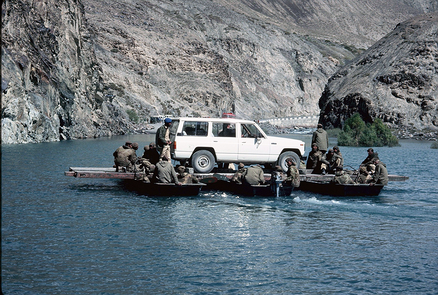
The rest of us are taken across in small groups so as not to capsize the makeshift raft.
Not always easy going. With no roads, it was often a bumpy ride!
We finally reached Kashgar, the last town on one of the longest dead ends on the planet. On three sides, it is shielded by the Karakorum and Pamir mountain ranges, and on the fourth by the Taklimakan Desert, whose name translates as, “The Go In And You Won't Come Out Desert.”
People watching at the Sunday bazaar.
On a small ship through the Three Gorges before they were flooded to build the world’s largest electrical power station. This area of three adjacent gorges along the middle reaches of the Yangtze River is known for its spectacular scenery.
Local fishermen in the early evening mist.
Locals claim to have invented polo and their version, played by rugged mountain men from the districts of Chitral and Gilgit, has little of the money, pomp or even rules of the genteel game played at Ascot. They swing their mallets like scythes, hitting other men as often as the ball.
The 800-mile Karakoram Highway (known informally as the KKH) has been called the "Eighth Wonder of the World." The highway follows a route that in the past was a major part of the Silk Road, a historic trading route. It took 20 years to complete in almost impossible conditions and had only been open for 10 years when we travelled on it—the world’s highest paved international road. We began in Hasan Abdal in the Punjab province of Pakistan, going to the Khunjerab Pass in Gilgit-Baltistan, and finally crossing into China with a steep climb through the Karakoram mountains, which reached a height at the top of 15,466 feet. It was both a frightening and exhilarating experience.
Just before reaching the Chinese border, the road had been destroyed by a glacier that had broken apart and crashed down the mountainside, creating a large lake cutting off access to China. Here we are discussing the situation with a Pakistani army general who was facilitating our journey.
The army solved the problem of getting across the glacier lake. Army engineers built a small, wobbly raft to ferry us across. Here goes our car. You can see our Chinese hosts waiting anxiously in the distance on the other side for our safe arrival.
This is now on the Chinese side of the Karakorum, continuing in the ancient footsteps of the Silk Road travellers where there are no roads—just the beauty of the landscape before us.
Another beautiful lake in Xinjiang, the furthest western region of China.
A bootmaker at the Kashgar Sunday Bazaar, which sprawls over a huge area of delicious foods, unrecognizable smells and the sale of all manner of items, including live animals. It was once the original global market, the point on the Silk Road where empires came to trade. Even today, the population of Kashgar reputedly swells by 100,000 on Sundays for this memorable event.
Almost all of the stalls are maintained by the indigenous population of approximately 8 million Turkish-speaking Muslim Uighurs who have as little in common, culturally, linguistically and religiously, with the dominant Han Chinese as the Tibetan Buddhists. Their struggle for independence has been just as brutally repressed.
One of the villages along the river that would be completely flooded in the 1990s. The villagers were part of approximately 1.2 million people who were relocated in order to construct the controversial dam.


